Tuesday, May 28, 2019

Steamboat - Grand junction - Moab


Grand Junction - Gateway - Paradox - Moab

A email note from Martin in NZ with the simple headline of - here is one for you and Brandi
No words in the email - just this note

Biking the Open Road in Colorado, With a Few Bumps Along the Way
https://www.nytimes.com/2018/10/15/travel/biking-the-open-road-in-colorado-with-a-few-bumps-along-the-way.html?nytapp=true

I read it and sent it on to Brandi and soon we were looking at the San Juan Hut system web site. It was Thursday and we spent much of that night looking at accommodation and the route while waiting on an answer from the San Juan Hut system.
Saturday - ‘yes we have available date of the 24th  Weds - confirm with a credit card and then fill out online waiver forms’ - funny signatures on line and hey presto - just 4 days from a email to being booked - thanks Martin.

Weds morning and we are off.  Bikes loaded in the little pickup - standing upright. A small road trip alongside the Colorado River for much of the way - through the depths of Glen Canyon and out to emerge into the orchard land of Grand Junction

Our immediate destination is Browns Cycles and we get there easily thanks to Google directions. Located in the old town it feels far removed from the hustle of ‘the strip’ that we have been driving though for 20mins since we left the highway.


Browns Cycles has our package of keys and maps from the San Juan Hut system.  After a nice chat to the owner we return to our car and park it where ?  Well the library car park seems ok - better than on the street.  ( we hope it there when we return )
The shop owners was worried about the time of day - thought it was bit late to be leaving for  50 mile ride - but hey - he didn’t know who we were.


Packs squared away - little truck parked up and we are off.  Trying to follow instructions on the Garmin and from memory but pretty soon I am navigating by what feels good. Follow this bike path - cross the river (yes the Colorado again) and along a highway - mmm not so much fun, but going in the right direction (missed the quiet back roads)

Soon our right turn onto the Scenic Byway / Highway 141 that leads over the hill to Gateway
The shop owner said - “9 mile hill we call it” and soon enough af

The plateau is actually slightly chilly and we ride with wind vests on before crossing the divide and starting out descent to Gateway.
ter a departure photo as we cross ‘the river’ again, we hit ‘9 mile hill’.  It’s not bad really - a little canyon crawling up to eventually get up high on the Uncompraha Plateau at  About the 20 mile mark


The roads are tar but not smooth with many ‘join cracks’ but at least at this point we are going downhill and we descend quickly the last 20kms to the small - one general store - town of Gateway.  A couple pics just on dusk of the store and on - only a hundred meters or so as my garmin map turns hard right.  along a dirt road - thru a gate and over in the distance the hut.  Negotiating some puddles (it has been raining here off and on for the last 11 days) and we are there.

Our oasis in the wilderness - next to the Dolores River - away from the hustle and bustle of every day life.  No other bikes outside - maybe we have the hut to our selves. Sure enough no one inside and at this time of night - I don’t expect any.


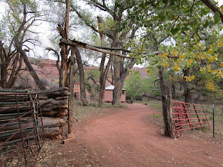
I hustle to get the gas lights going before its to dark to, see while Brandi takes photos of an old hut back down the track.  Once we have light we take a little time to inspect the hut.  They said fully stocked and that is what they meant - each bed has a sleeping bag on it, the cupboards when open are full - tins of every  type line it 5 deep - even a row of the famous American SPAM.

Two coolers on the floor - one full of ice and cold drinks - beer, water and sparkling
The other - a big chest opens up to reveal drawers of fresh legs  / bacon / eggs - they really did mean fully stocked.

Chilli beef and noodles for me with a beer and Brandi choses SPAM - but after a couple mouth fulls the remainder goes in the bin.

Dark outside now and the sky is full of stars - no light pollution out here.  We sit for a while and then it time for snuggling down into out new liners and the hut bags - standard Coleman bags but surprisingly warm.

Dawn and pee by the Dolores and back to snuggle down together to get a few more zzz’s

We must be tired as it’s after 0900 the we finally emerge from the bags and set about getting on the road again

83kms    3hrs 47mins


Friday, March 29, 2019

Phippsburg to Stagecoach Lake


The weather is still cold and I’m keen to do some more river running.
The 21st Feb we head south to the town of Phippsburg (dropping on car at Stage Coach Lake)
Google maps tells me that its about 10 miles (16kms) from Phippsburg to our take out at Stage Coach lake camp area

It’s funny but all my references have us river running - why ? Because that is exactly what it felt like.
Launch point  Rout County Road 12 - just prior to Phippsburg. Find a safe car park and wander a couple hundred meters to the bridge and push off. Next stop Stagecoach Lake.


The river shows all features of an old flood plain with multiple and I do mean multiple twists and turns where it winds back on itself.

We are waved off by the local coyote who watches us  leave with much interest. He obviously has been using the river a a thoroughfare as his tracks lead us downriver. Soon we are lost in this floodplain - the views keep changing - at one stage we are virtually going up river and south, and then around the next corner west and then north.

Giant ‘willows’ show up down river and soon a couple bald eagles reveal themselves perched high in the branches   We are in their home country and dodging some ‘open water looking leads’ we edge closer - hoping for the ultimate view.  One doesn’t like the couple and peals down over our heads and as he heads upstream. The other eagle sits aloof and simply watches us passing. Very cool

We continue downstream and surprise some geese who leave their open water pond in a hurry - wings flapping hard against the river snow. Each push of the wings leave distinctive marks on the snow.


Around the next corner a beaver watches for just a moment and then dives and disappears. First wild beaver sighting for me and now I look for the dam - no sign of that, but a bit further down a  beaver lodge is seen on the bank, but it seems to far away from the water for a underwater entrance - but I guess there is one

Lots of twigs and branches have been harvested by the beavers for food during the inter and I guess they are all stored in the lodge.  …………….


We continue our river journey - only once being forced onto the bank to pass exposed water.

The river continues its serpentine way - past the power pole on the hill - which we have seen from all sides - past three curious horses - are we going to give them food. They are unsure of us and keep their distance in a snow covered paddock

A steady downstream wind helps us mostly - although at times we turn across and even against it.  Seemingly open leads of water are actually frozen but we don’t trust them and stay our distance mostly - only occasionally using them as high speed sections - it’s easier than the snow covered sections. No load cracks - so we feel ok.


At about the 5kms mark we are close to Rout County Road 14 - the route from Stagecoach to join 131 and then we move away in the valley as the river meanders. A couple oxbow bends - areas now cutoff form the main flow also offer us small shortcuts in our progress downstream

Our gamin bike computer records us moving at 5 km hr ie just over 3 miles an hour. Straight line distance is just over 7kms (4.5 miles) but we do more than 14kms (8.6miles) to get to the edge of Steamboat Lake. 
Here the journey changes - we leave behind the twists and turns and stride across the lake direct towards the Stagecoach Marina where we have parked our car. It’s only 2kms until we hit land again but he distances are deceiving on the open exposed area


We scramble across sand dunes of snow through snowy car parks until we find our transport - quietly nestled behind a large snow bank where we left it.  Journey complete.

Next year - Steamboat to Craig - or as far as the frozen ice of the Yampa will allow.

The record
distance traveled 14.13kms - 8.6miles
Time 2:48 mins
5kph  average speed - 3miles hr
480 calories used  (according to the Garmin record)
Temp average  16.1 C - 60 degrees


Lower Yampa - Chuck Lewis to 5th Street


A descent of the Yampa from source (almost to Steamboat) - to be continued in the winter of 2019-20

A while ago (mid Jan) I saw tracks on the Yampa and asked locals if they had ever skied the Yampa at all - the answer was negative.
I started planning and finding a time to do it and then read your article in the Pilot and Today


Subsequently
The first little checkout revealed surface water at Walton Pond but on Feb 19th we did the section from Chuck Lewis State Wildlife Park to 5th Street Bridge and then on Feb 21st from Phippsburg to Stagecoach Dam Marina

The last section revealed coyote, 3 bald eagles many geese and innumerable switchbacks - a great day out.


River Running on the Yampa
After seeing tracks on the Yampa from rive road I started planning to follow the example of a local and explore the river in winter guise.


The first little checkout revealed surface water at Walton Pond area and we only made a foray upriver for a short distance, but the idea stayed and one after after skiing I bundled up Brandi and our gear and drove to what seems a likely put in - the Chuck Lewis State Wildlife Park.
I’m really thinking that this is just raft - river running but done in the winter on XC skis. We are soon lost in the meanders of the upper river. Each twist and turn revealed new vistas of the mountain and the valley. Past the jumping ramp, abandoned cars long over grown by river bank vegetation - was that a 1950 Ford or Cadillac - hard to tell with only a small piece of the bonnet and guard showing


As we near the Walton Pond area ducks explode from a small section of open water and circle back overhead looking for more clear water.

So far the ducks are the only actual wildlife we have seen but tracks aplenty have shown that the river is a highway for small wildlife in the winter - fox and rabbit tracks mainly.

At Walton Pond we have to decide - call it a day or push downstream (Brandi has an appointment in town at 5)

We push on and now some of the structures are more familiar - the road bridge back from River Road, and then further down we cross under the rail line a couple times. Under the bridges the river is clear of snow - and we question ourselves - Is that ice thick enough ?? I prod at the surface and am reassured but there are still some noise as we bend to cross under the support structure - mostly its just surface ice that breaks under our skis but still  ??


As we near town we have the occasional wave from River Road - the cars slow and the drivers peer out the window to actually confirm that there is someone skiing on the Yampa. Not sure what they are thinking - crazy or jealous ?

 Walkers and cyclists on the Core Trail wave as they pass.

At the last train bridge as we near town we hear the hoot in the distance and come back upstream to witness the train traveling over the bridge. The engineer spots us and we get another toot and wave from him as well.


Now as the Yampa tips downward a bit more, there is more open water and a near splash down (lucky just the back half of the skis) forces us onto the bank just 100meters prior to the 5th Street Bridge. A couple quick photos - ‘we were there’. and off strolling through town - skis over the shoulder.


Another day skiing in Steamboat.

The Record
Distance travelled 8.1kms / 5 miles
Time 1:39
4.9kph average speed / 3 miles hr
244 calories used (according to Garmin.
Temp average 13.4C  /  56F